Tuesday, July 27, 2010

Final Dive Complete - Current Meter Retrieval

Our mission ended on a great note with our return to the Gully MPA. Upon reaching the bottom we discovered many patches of the small gorgonian coral Acanella arbuscula, some of which were collected using mesh bags (see right) for a reproductive study conducted by Dalhousie MSc student Lindsay Beazley.


We continued along course to collect one of two current meters deployed in the area. Once collected, we travelled up slope and discovered a cliff face beaming with large gorgonian corals such as Paragorgia arborea and Primnoa resedaeformis, and glass sponge. This area represented the first concentration of P. arborea colonies observed on the entire trip!


Once we left the cliff face we travelled towards the final current metre, which we collected and then made our last ascent of the mission.

Monday, July 26, 2010

Mission Summary to Come

Stay tuned to the blog for the mission summary in the days following the ship's return to Halifax. The final dive will soon be underway in the Gully MPA and when completed will cap off nearly 3 weeks of spectacular science. Upon our return, the hard work of analyzing the data collected during the mission will begin. Thanks to everyone for tuning in, everyone on board is sincerely grateful for your interest in our work. Talk to you soon.

Sur le chemin du retour

Après 19 jours en mer nous sur le chemin du retour. Nos plongées à l'Orphan Knoll ont été généralement très intéressantes, surtout pour comprendre la géologie du Knoll et des monts sous-marins situés sur son sommet et en périphérie. Nous avons aussi collecté beaucoup d'échantillons exceptionnels qui pourront après analyses nous donner des informations précieuses sur la nature chimique et la dynamique des océans pendant les derniers millions d'années. Le temps brumeux, la mer parfois agitée et des problèmes techniques sur le ROPOS nous ont forcé à supprimer certaines plongées, mais la mission a été dans l'ensemble un grand succès. Nous devons être ce soir au site de notre première plongée dans le parc marin du Gully pour récupérer les équipements que nous y avons déposé qui ont mesuré pendant cette vingtaine de jours la force et direction des courants marins.

L'ambiance à bord est à la fin de mission. La plupart des membres de l'équipe classent les échantillons collectés et les préparent pour le débarquement du navire. D'autres s'assurent d'organiser les données informatiques (vidéos, données de navigation, etc.) et de les distribuer aux différents membres. Le Hudson devrait arriver le 28 Juillet vers 8h puis repartir plus tard le même jour avec une autre équipe scientifique. Notre équipement doit donc être débarqué rapidement. De plus, nombre d'entre nous devons participer à une conférence de presse le 28 en fin de matinée pendant laquelle nous présenterons les fait saillants de la mission et répondrons aux entrevues des médias. Beaucoup de choses à préparer!

Friday, July 23, 2010

Orphan Knoll dive 3 : Summary

The elusive Orphan Knoll mounds and the source of the 1978 sub-fossil Desmophyllum dianthus………have been found!

The search for the mounds was a long and for the better part of a day, it was looking like we were following inaccurate data; as the thirty-plus year position data wasn’t as precise as today’s global positioning systems.

Despite the lack in accuracy of historic data, the sonar imaging system accompanied by skilled pilots belonging to ROPOS was instrumental in finding the never seen or accurately sampled Orphan Knoll mounds.

The mounds appear to be formed of bedded limestone; however, further analysis will be done to confirm the composition and age of the rock and dead Desmophyllum dianthus.

As with the previous Orphan Knoll / Seamount dives, unrecognizable species of coral and sponges were seen………. Orphan Knoll dive 3 was no exception. Unique black coral species, sponges, unique anemones, Dumbo squid, etc.
In summary, the Orphan Knoll dive 3 was a success both geologically and biologically.

del.icio.us Tags: Orphan Knoll,Deep-Sea Sponges,Cold-Water Coral,Desmophyllum dianthus

Thursday, July 22, 2010

Mooring Not Found

Despite our best efforts (right - seach pattern from screen shot of ROPOS navigation system) using the sonar on the ROV ROPOS to hunt for Fisheries and Oceans Canada mooring, we were unable to find it at its last known location.

To compound issues, upon retrieval of ROPOS to the ship, their umbilical developed a problem. Through the night the ROPOS team has been re-terminating the cable to prepare it for deployment later today. Despite initial reports that the cable would not be fixed for 24 hrs (9 pm tonight) it appears as though they will have completed the repairs nearly 9 hrs earlier. We should be deploying at Site 14 by noon today (July 22).


Please stay tuned for updates on our progress.

Wednesday, July 21, 2010

Courte tranche de vie

Pour ne pas parler que de science, voici un peu d'anectodes sur la vie à bord du Hudson. Tel que mentionné dans un article précédent, l'équipe scientifique est divisée en deux: les chanceux qui travaillent de 6 heures du matin à 6 heures du soir, et les autres (appelés par certains "les zombies") travaillant de 6 à 6 la nuit. Les membres des deux groupes se rencontrent rarement à part pendant le déjeuner et le souper. Les personnes travaillant de nuit ont, après quelques jours d'ajustement, un horaire complètement inversé par rapport à nous. Leur journée commence vers 17h lorsqu'on les voit émerger de leur chambre les yeux fatigués, un café à la main. Certains prennent ensuite un jus de fruit et des céréales pour le souper pour bien démarrer leur journée. La nuit, le bateau est fort d'activité alors que nous dormons. Et le plus intéressant est que leur soirée débute tôt le matin. Il est 7:05 du matin lorsque j'écris ces lignes pour le blog et quand je suis passé au salon il y 30 minutes, j'ai vu un groupe travaillant la nuit en train de regarder un film en buvant une bière ou un verre de vin avant d'aller se coucher... Scène étrange à 6:30 du matin...

Sinon, côté science, la seconde plongée à Orphan Knoll s'est terminée hier soir vers 23:00. Cette plongée visait à monter deux petits monts sous-marins au sud-ouest de celui de la première plongée. La découverte la plus impressionante a probablement été lorsque que le ROPOS est arrivé sur le fond marin au début de la plongée et a atterrit au milieu d'un champ de ce qui semble être des nodules de manganèse, sortes de boulets de tailles diverses formés par la concrétion successive d'oxyhydroxydes de fer et de manganèse. Ces nodules peuvent croître de 1mm-1cm par million d'années et peuvent, comme les anneaux de croissance des arbres, être analysés pour étudier l'évolution de la chimie des océans pendant les derniers millions d'années. Une découverte qui a fait bien des heureux parmis les géologues à bord!

Plusieurs personnes m'ont demandé si nous avons vu lors de nos plongées des impacts des activités humaines. Surprenament, non, mais il faut dire que nous plongeons dans des environnements peut propices à la pêche. Toutefois, nous avons vu un fillet de pêche lors de l'une de nos premières plongées (voir photo).

Tuesday, July 20, 2010

Orphan Knoll Dive 3 : 1978 Dredge Location / NE Mound Field

Around forty years ago, mounds on the NE corner of Orphan Knoll were discovered. The theories as to what the mounds were comprised of are various (authigenic carbonate, hydro-thermal activity, up-turned blocks, etc.) but unconfirmed. Dive 3 on Orphan Knoll will hopefully help clear-up the mystery of the mound composition.

The mound field on the NE corner of The Knoll were taken in 1979 and 1980. The data loosely visualizes the surface of The Knoll with a visible swath of ~50 Km. The low resolution black and white imagery, historic depth measurements and 12 KHz and 3.5 KHz seismic profiles are all the data that has been used to identify these mounds. There are roughly 250 mounds, whereby the geological origin remains unknown..........until now.

A hard Scleractinian coral, Desmophyllum dianthus, was found in 1978 by the Geological Society of Canada (GSC), lead by Dr. C. Keen. The fossilized and alive coral suggests that these mounds could be adequate substrate for deep-sea coral growth.

Determining the marine biology of these mounds and the geological composition of these mounds will hopefully end the debate on the origin of these mysterious mounds.

The dive plan attempts to traverse 3 mounds where the 1978 dredge locations were taken.


Orphan Knoll Dive 2 : Summary

7_20_2010 1_39_21 PM00006197 bedrock nodules

Unexpected Marine Geology! Big Vase-like sponges and Black Corals! What an unexpected dive!
Geologically, the initial view was of a limestone-like bedrock with possibly Manganese nodules scattered on the sea floor. The mounds on the SE ridge of Orphan Knoll appear to be a series of volcanic mounds.


Some unrecognizable species of sponge and some unconfirmed Black Corals (Antipatharian) were some of the major biological highlights of these SE mounds (shown above).

The dive finished with a high-resolution IMAGINEX multibeam transect over top of the second mound.

The next dive, Dive 3, is a DFO mooring recovering dive with the chance to see what is living at the top of the south Orphan Knoll canyon feature.

Picking up a Package

Over the last few years, researchers with Fisheries and Oceans Canada have been compiling physical oceanographic data on the water masses and current circulation around Orphan Knoll. In addition, data on abundance and diversity of pelagic zooplankton as well as the concentration of bacteria around and across the knoll has been collected during this time.

As part of this initiative, moorings with attached near bottom current meters were placed at strategic locations around the knoll (right inset). The Fisheries and Oceans Research team conducting this research on the Knoll made a trip here in May. In an effort to gather another 2 full months of current meter data, the DFO team left the moorings in place in hopes that they could be retrieved during our mission.
Tomorrow morning we will begin the first, and most challenging, of 3 mooring recoveries. Each of the moorings is equipped with a release that is triggered remotely by
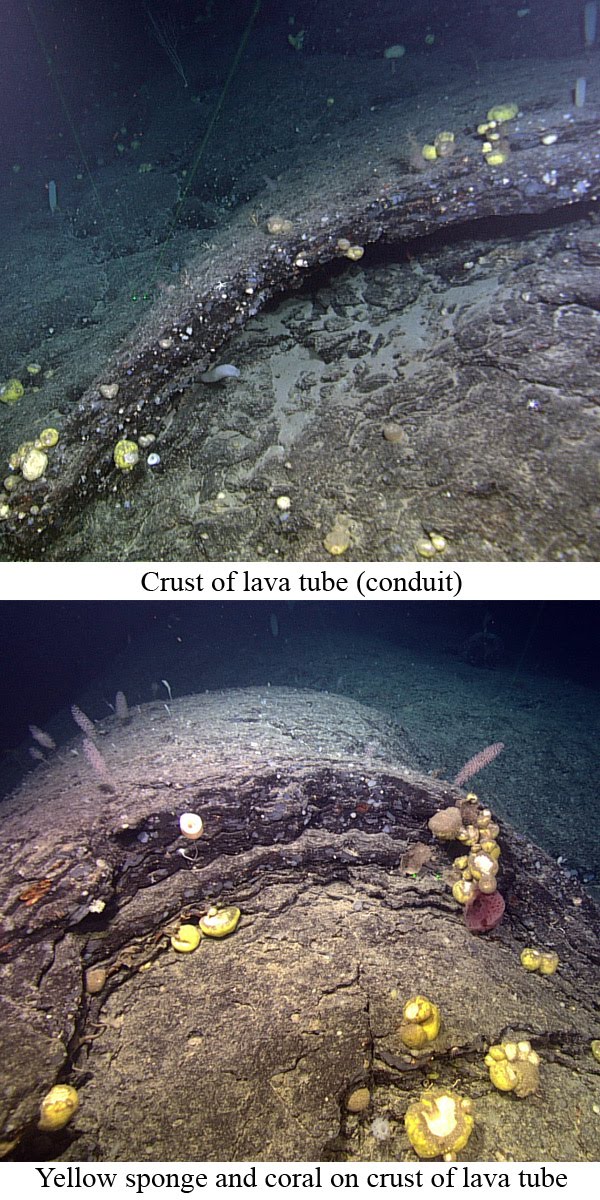
 DFO staff from the ship (left). During the initial deployment, the signal for one mooring (highlighted in blue) was lost at ~1500 m water depth. It is unlikely that the equipment on the morning will be released remotely from the ship, thus ROPOS has been tasked to find and recover this mooring.

Upon reaching the mooring's last known location, ROPOS will turn on their long range sonar (100 m) in an effort to visualize the mooring at a distance well beyond the scope of their 2100 watt light bank. Once found, ROPOS will waypoint the location and then begin a 5 km grid transect to profile the ocean bottom near the current meter (right). At the end of the transect, ROPOS will return to the mooring location and bring it back to Hudson.

The dive will take approximately 15 hrs to complete including the search for the mooring.

Monday, July 19, 2010

Volcanic Dive


At 3000 m ROPOS began maneuvering up the slope of a long since inactive volcanically formed seamount just south of Orphan Knoll. Along the mountainous ascent, researchers on board observed pillow lava and collapsed lava tubes (conduits), volcanic features that form when hot lava meets cool ocean water (right). The seamount can trace its volcanic origins to the spreading of the Atlantic governed by the Mid-Atlantic Ridge.

A number of taxonomic and geological collections were made, including volcanic rock and unidentified sponge and coral (Below). This 20 hr dive finished at about 2000 m with every collection container on ROPOS full to the brim. Taxonomists and Geologists alike will now patiently classify and catalogue all of the specimens in the ships general purpose lab. Rocks collected during this dive will be utilized to determine the age of the seamount. For more images from this dive click here (OK1).

ROPOS should be back in the water within 5 hrs upon recovery from this dive (July 20th, 4 am AST). A synopsis of the second dive on Orphan Knoll is available below.


Orphan Knoll Dive 2 : SE Ridge Mounds

The Orphan Knoll Dive 1 : Orphan Seamount, proved to be an interesting geological and biological dive ; whereby, possible new species of coral and sponge were collected and photographed and large pillow basalts, lava tubes and large bedrock outcrops made for an exciting geological component.


The first official ROV dive (Dive 2) on the Orphan Knoll will be on the SE ridge ~30km near the Orphan Seamount (Dive 1).


Dive 2 covers three mound features that are generally 100m tall, in roughly 2900m of water depth. Dive 2 plan is shown below.


The origin of these mounds could be linked to the origin of the NE and SW mounds. The origin of the Orphan Knoll mounds could possibly be formed by cold-seeps, hydro-thermal activity, biological (i.e. coral reefs) or through some unknown method. Determining, through in situ rock sampling, the origin of the Orphan Knoll mounds is of primary concern with a secondary objective; to determine what marine biology lives on the Orphan Knoll.


L'ascension du volcan!

Avec cette journée s'achève notre première plongée dans la région du Orphan Knoll, un lieu relativement énigmatique pour la communauté scientifique, tant pour ses mystères géologiques que biologiques. En effet, l’Orphan Knoll est probablement un morceau (énorme) de continent qui se serait détaché et retrouvé au milieu des fonds marins. Le Knoll est entouré de nombreux monts sous-marins et cette première plongée avait pour objectif de monter le long d'un d’entre eux (le plus important de la région). Le ROPOS a plongé vers 4h ce matin à une profondeur de 3000 mètres. Fait cocasse, 3000 mètres est la limite de plongée possible pour le ROPOS, car cela correspond à la longueur du câble qui le relie au navire. Le site de notre plongée s'avéra être à 3040 mètres ce qui nécessita quelques réajustements de position pour ne pas atteindre la limite du câble... Comme quoi la science essaye de toujours repousser les limites du possible! ;-)

Une fois sur le fond nous avons vite eu un aperçu de la géologie particulière du site. Les roches étaient d'origine volcanique, confirmant l'hypothèse que cette montagne est en fait un volcan (inactif) éteint! Nous avons pu voir de magnifiques coulées de lave solidifié depuis probablement des millions d'années sur laquelle se dressait de nombreuses éponges et coraux. La montée a été ponctuée de zones riches en biologie sur un substrat de lave, à des zones plus pauvres sur des sols recouverts de boue et de sable. Les géologues comme les biologistes ont été émerveillés par le paysage qu’on a rencontré par moment. Il faut noter que la protection des monts sous-marins est très importante au niveau international mais que ceux-ci restent encore peu connu. Nous avons collecté ce matin les premières images et échantillons d’un mont sous-marin dans le Canada Atlantique! (bon… techniquement on était en zone internationale mais le cœur nous dit bien que c’est le Canada…).

Nous avons, comme dans nos plongées précédentes, vu un grand nombre d’espèces rares, incluant la découverte possible de nouvelles espèces. L’image ci-contre montre un exemple d’éponge colorée inconnue de nos biologistes marins. Nous avons vu des poissons dont quelques chimères. Nous avons collecté tellement d’organismes intéressant que nos boîtes à échantillon se sont remplies pour la première fois avant la fin de la plongée, rendant les biologistes frustrés de ne pas pouvoir collecter par la suite certains coraux et éponges uniques.

La plongée va se terminer vers 21h ce soir et nous nous rendrons alors au site suivant qui va permettre d’explorer des montagnes sous-marines plus petites, un peu à l’ouest de notre position actuelle. A suivre...

Sunday, July 18, 2010

Orphan Knoll Dive 1 : Orphan Seamount

The Orphan Seamount, found 620 Km east of St. John’s, NL, is a 2000m tall submarine feature that starts at a depth of 4500m.


Even though the Orphan Seamount has never been explored or studied, the shape and relation to Orphan Knoll suggests that it is probably a volcanic seamount.

In 2001 the USCG Healy collected high resolution multibeam imagery of the Orphan seamount and the SE ridge of the Orphan Knoll.

The CCGS Hudson and CSSF ROPOS are being used to collect biological, geological and seismic data on the Orphan seamount.

The dive plan for the Orphan Seamount will start on the NE side of the seamount and finish on the top of the seamount. The dive site and the dive plan is shown in the images below.


Seamounts near Newfoundland and Labrador have not been studied with the aid of remotely-operated vehicles (ROVs) before. The CSSF ROPOS is an ROV that can reach depths of ~5000m below sea level. The current floatation package installed allows ROPOS pilots to dive 3000m below sea level.

Seamount’s in other areas of the world have shown to be hotspots of biodiversity for many different types of invertebrates, including cold-water corals and sponges.

These invertebrates are living on unique and sometimes hostile substrate (e.g. hydro-thermal vents, black smokers, etc.).

The geological constitution and origin of this seamount coupled with unknown deep-sea biological fauna make exploring the Orphan Seamount an exciting adventure!

Flemish Cap Complete

The last dive on Flemish Cap was certainly not the least. This one dive held what taxonomists believe to be 2 entirely new species of cold-water corals (right). After struggling to reach the bottom because of the strong deep-ocean currents in this area, ROPOS took a few critical samples and began the arduous 12 hr journey up the slope towards the top of the cap. This dive spanned almost 1200 m of water depth from beginning to end and displayed a vast array of habitats, ranging from cliff side terraces lined with complex glass sponges and never before seen coral species to sandy bottoms which were comparatively devoid of life. The dive finished strong at 1300 m by providing scientists on board with a view of spectacularly dense beds of large white sponges of the family Geodiidae. Closure areas implemented by NAFO in this area were based on by-catch records of this habitat forming sponge (left). For more images from this dive click here (FCP6).

Despite weather and emergency delays in schedule, the dives on Flemish Cap have proven successful. These dives have given researches a glimpse into the deep waters of the slope ringing the Flemish Cap. Taxonomic samples have provided voucher specimens for video analysis that will take place once on shore. Incidentally, these collections have lead to some exciting discoveries; including 11 possibly new species and many more rarely encountered organisms. Geological samples collected and habitat classification conducted on board during dives in Flemish Cap will provide some insight into the geological origins of the cap while simultaneously enhancing our understanding of the driving factors affecting the distribution of deep-sea organisms in the area.

As well, 2 dives were specifically focused on surveying key portions of recent NAFO closure areas. The first of these dives on Flemish Cap successfully investigated the impact of trawling gear on vulnerable marine species. The data generated by transects run through both trawled and un-trawled ocean bottom within the footprint of an EU trawl survey conducted in the area in 2007, will provide researchers with some indication of the sustained legacy that trawling may have on deep-sea sponges and corals and other associated organisms. The second closure area dive was particularly interesting as it provided a glimpse into an undisturbed world of habitat forming sponges. Data from this dive will be used to modify existing models of sponge distribution and will assist in describing the species associated with these important biological features.

We are currently making the 9 hr steam north to begin a series of dives at Orphan Knoll. Shawn Meredyk, a Memorial University student conducting a Masters of Science Degree in Environmental Science specializing in the surficial geology and marine biology of Orphan Knoll, will provide a summary of activities for the first dive at this never before visited location.

En route pour Orphan Knoll

Suite à l’évacuation médicale héliportée hier, nous sommes retourné au Bonnet Flamand. Une fois sur le site, des vents soufflants à environ 30 kts (soit près de 55 km/h) produisaient des vagues qui faisaient trop tanguer le Hudson pour pouvoir envisager de mettre le ROPOS à l’eau de manière sécuritaire. Nous avons donc attendu patiemment une accalmie, gardant notre position.

Le ROPOS a pu plonger hier soir vers 20h pour une exploration commençant à 2400m de fond pour voir la faune sous-marine dans une zone devant devenir une aire protégée pour les éponges de mer. A notre surprise, nous avons aussi trouvé une grande quantité de coraux et d'éponges le long d'escarpements rocheux situés à l'extérieur de l’aire prévue. Deux nouvelles espèces biologiques ont aussi été découverte aujourd'hui, portant le nombre probable de nouvelles espèces à 11 depuis le début de la mission! Comme quoi les fonds marins nous réservent encore de nombreuses surprises!

200 litres d’eau provenant de la masse d'eau de surface (le courant du Labrador) ont été pompés lors de la remontée du ROPOS. Cela termine l’échantillonnage des masses d’eau entourant le Bonnet Flamand. Ces pompages permettront de corréler les signatures géochimiques de coraux (Desmophyllum) échantillonnés sur les flancs du Bonnet avec les masses d’eau dans lesquelles ils vivent. Des coraux fossilisés plus anciens ont aussi été échantillonnés par le ROPOS. Ceux-ci seront ramenés et analysés en laboratoire (au GEOTOP à Montréal), afin d’en déterminer l’âge et la composition. Cela permettra de déterminer l’évolution des conditions géochimiques de cette partie de l’Atlantique Nord, qui sont elles-mêmes à relier aux changements climatiques (naturel et humain).

Nous sommes maintenant en route vers Orphan Knoll ("Butte orpheline"??) par une mer agréablement calme. Notre prochaine plongée devrait commencer la nuit prochaine dans une zone encore inexplorée pouvant révéler de nombreuses surprises!

Friday, July 16, 2010

Le Blog maintenant disponible en français!

Plusieurs d'entre vous ont demandé à avoir une version de ce blog en français. Comme la mission inclue plusieurs scientifiques francophones nous sommes heureux de fournir des informations dans les deux langues, mais pas sous la forme d’une traduction. Chacun pourra ainsi rapporter les événements à sa manière et les personnes parlant les deux langues pourront aller chercher plus d’informations! Notons en passant que Pêches et Océans Canada n’est responsable en rien du contenu en français de ce blog qui est écrit par des universitaires de l’Université Memorial de Terre-Neuve et de l’Université du Québec à Montréal. :-)

Nous n’allons pas reprendre tous les événements depuis le départ de la mission mais en voici les grandes lignes. Les objectifs généraux de cette mission scientifique sont de mieux comprendre la biologie, l’écologie et le contexte géologique des coraux et éponges vivant dans les eaux profondes de l’Atlantique du Nord-Ouest, principalement au large de Terre-Neuve et Labrador. Les coraux et les éponges sont des organismes fragiles, succeptibles d'être affectés à long terme par les pratiques de pêche, mais important pour la santé des écosystèmes marins. La mission en mer se fait sur le navire de la garde côtière canadienne CCGS-Hudson et utilise le submersible ROPOS, un robot d’environ 2 mètres de haut et 3m de longueur qui est attaché par un long câble et dirigé à partir du bateau. La mission implique 19 scientifiques (dont un étudiant espagnol), huit personnes travaillant pour ROPOS et tout l’équipage de la garde côtière pour l’opération du navire. L’équipe scientifique à bord du bateau combine des biologistes, des géologues et des géographes s’intéressant à des questions diverses reliées aux coraux et éponges des eaux froides. Une partie de notre équipe travaille de 6h à 18h tous les jours et l’autre de 18h à 6h la nuit, pour permettre d’opérer 24/24h et 7/7j (vous voyez, vos impôts font du chemin!).

Nous avons quitté Halifax jeudi il y a 8 jours, le jeudi 8 Juillet, et avons fait six plongées avec le ROPOS depuis. Chaque plongée dure plusieurs heures, souvent entre 10 et 20 heures. La première plongée à Halifax a permis de tester et calibrer notre équipement. Une seconde plongée le lendemain dans la zone de protection marine du Gully a permis d’installer des appareils allant mesurer les courants sur le fond marin. Le reste des plongées a ensuite eu lieu à l’est du Bonnet Flamand (au nord-est des Grands Bancs), dans des profondeurs allant de 3000 mètres à environ 1000m. Pour chaque plongée nous avons accès à des vidéos à haute résolution du fond marin grâce à des caméras numériques installées sur le ROPOS. Pendant les plongées, les images sont communiquées en direct par satellite au Musée Canadien de la Nature (Ottawa, ON), au musée The Rooms (St, John’s, TNL) et à l’auditorium de Pêches et Océans Canada à Dartmouth (N-É). Le ROPOS est aussi équipé de deux bras articulés qui peuvent collecter des échantillons.

Un accident hier matin qu'a eu l’un des membres d’équipage nous a forcé à retourner en direction de St. John’s (Terre-Neuve et Labrador) et un hélicoptère de la garde côtière a récupéré le blessé tôt ce matin à une centaine de kilomètres au nord de la plate-forme de forage Hibernia, à l’est des Grands Bancs de Terre-Neuve. Nous naviguons à présent en direction de notre dernier site de plongée situé au nord-est du Bonnet Flamand, après quoi nous nous rendrons plus au nord pour une série de plongées autour du Orphan Knoll. La mer est plus agitée que les jours précédents (c’est d’ailleurs tout un défi d’écrire ce blog sans avoir la nausée!) mais nous avons pour la première fois un beau soleil et une température assez agréable sur le pont qui permet à certains scientifiques de se faire bronzer et à d'autres de manger de la crème glacée pendant notre trajet jusqu'au prochain site!


Revenez voir le blog demain! Nous vous donnerons des détails sur la plongée qui devrait commencer vers minuit ce soir (heure de l’Atlantique). Et n'hésitez pas à poster des commentaires ou questions, nous serons heureux d'essayer d'y répondre.

PROFILE - REUBEN MILLS

In the world of ROV designers and operators it's not uncommon to spend more than 120 days a year at sea. If you were in this line of work for 25 years, that would be a full 8 years of your life away from all things home. That's 8 years of working, eating, drinking, bunking, partying, consoling, being consoled, fighting, laughing and just plain living with the people you work with. It is not a wonder then, that the staff from the Canadian Scientific Submersible Facility are such a tight knit group. To a person, each operator and navigator for ROPOS (Remotely Operated Platform for Ocean Science), feels that while they are contracted out to perform specific functions (in our case scientific research), the lasting bond they have created with each other feels more like a family one than a work one.

We've asked to profile one of the ROPOS operators to get a sense of how one chooses this interesting and exciting career path. Below is my "blogger"view with Reuben Mills, a 33 year old self confirmed "big personality" and Mechanical Engineer with the Canadian Scientific Submersible Facility (CSSF), born in Winnipeg, Manitoba and currently residing in Victoria, British Columbia:

Blogger: "What did you want to be when you were a little kid?"


Reuben: "I don't know really. I liked hockey, played a lot but I knew that was not what I wanted to do. Well, I guess I always had an interest in building things as a kid, you know, knowing how things work, how they are designed, I always thought that was cool."


Blogger: "Where did you go to school?"


Reuben: "I went to school at Camosun College in Victoria. Actually, when I was going to school, I went to the CSSF to get some information on how to design Remotely Operated Vehicles because I was making one for a design class. After my visit, Keith Shepard (General Manager, CSSF) said I should come back after I finish school for a job".

Blogger: "So, what happened then?"


Reuben: "I didn't go back and I spent some time working in the commercial fishing industry out west, fishing tuna, herring, etc. I kind of lost my taste for it and decided to head south to work on some ships. It just was not what I wanted, so when I was on leave in 2005 I called Keith at CSSF and was offered a job nearly on the spot. Well, Keith did ask for a resume, but I started not long after that. It was great timing because they were doing a complete rebuild on ROPOS."


Blogger: "Where is the coolest place you've worked with ROPOS?"


Reuben: "Well, the furthest away I've worked is NZ and Fiji, but I love the east coast of Canada too. Really, every place we go has something to offer, its pretty diverse work."


Blogger: "Do you ever hope to do anything else for a career?"


Reuben: "Not really, I love my job, the guys I work with are great. This is the tightest knit group of guys I've ever worked with. It's amazing every day to work with your closest friends. We really are more like family."


Blogger: "What do you do in your down time?"


Reuben: "I work mostly. I'm constantly designing and fabricating things for CSSF and Highland Technologies clients. It's what I like to do. When I'm not working I'm usually haning out with my dog Buddy or kite boarding."

Reuben, Ray Morgan, Dan Cormany Vince (Vin/Vinnie) Auger, Steve Bucklew, Keith (Big) Tamburri, Jonathan Lee, Ian Murdock are all members of the ROPOS crew and have been intimately involved with pre-cruise planning and implementation of the mission plan. For more information on the CSSF click here.

Helicopter Lift

The injured CCG crew was air lifted to St. John's (right) and the Hudson has turned around and is heading towards Northern Flemish Cap to resume scientific operations.

This next dive will take us up the steep slope of north-eastern Flemish Cap starting in 2500 m water depth and ending 6 km up-slope in 1400 m of water. This dive will finish on the cap and cross the boundery of a NAFO closure recently implemented to protect high concentrations of deep-sea sponge. Maps of the dive (2D and 3D) are provided (bottom).

Details and imagery associated with this dive will provided upon its conclusion.


Thursday, July 15, 2010

Medivac

One of the ships crew has been injured and we are heading towards St. John's to get this person to medical care. The injury is not serious.

Over the next 2 days we hope to have video of previous dives playing at the BIO auditorium, the Canadian Museum of Nature in Ottawa and The Rooms centre in Newfoundland during our transit. We will keep you posted through the blog and twitter as plans are updated over the next two days.

On a positive note, this gives on board taxonomists time to pour through samples and take images of collections made over the last few days. As images from the lab pile up sample images will be posted to the blog for you to view. As well, an article featuring our work was published today in the Chronicle Herald.

Please keep following us on Twitter and this blog over the next few days. We should have time to put together some really great material over the next few days!

Wednesday, July 14, 2010

Flemish Cap Dive 4

This dive has been designed in a grid design around a European Union survey trawl line run in the same area in 2007. The organisims in this EU trawl included large amounts of the sponge Geodiidae and a few large branching corals. On this transect we will investigate the fauna within and surrounding the approximate course of the trawl survey. Few taxonomic collections will be made during the dive, but the video and imagery taken during the dive will be analyzed in detail to associate biology with relative location in relation to the suspected trawl track.

The dive track and the 3D profile of the dive are provided below:


Steep Cliffs Dominate Third Dive on Flemish Cap

Today's dive was another extraodinary venture into the complexity and beauty of the biology and geology of the deep water of Southern Flemish Cap. Today's dive was marked by dramatic 100 m plus mudstone (yet to be confirmed) cliffs, spotted with pink branching corals (Primnoa resedaeformis - right top), and prolific concentrations and diversity of sponge. Geological collections consisted of mudstone from the base of precipitous cliffs and other rocky outcrops.


Biological collections were dominated by soft corals (right - bottom) and other species of coral for which on board taxonomists had yet to identify. A selection of images from the dive are available by clicking here. We hope to have a number of microscopic and macroscopic photos from our taxonomy lab available online in the coming days. Please feel free to comment on the blogs.

Tuesday, July 13, 2010

Alien Environment Observed in Deep Water of Flemish Cap

The purpose of today's dive was to observe and catalogue the deep-sea creatures in an environment which has never been impacted by trawling or any other human induced mechanical disruption. By reaching 2969 m this dive tested ROPOS's limitations. In fact, this is the greatest depth that this ROV has achieved in its current configuration.

The bottom in this area was punctuated with large basalt outcrops (possibly of jurrasic origins?) covered in deep-sea species largely unknown or rarely observed by experienced taxonomists on board the ship. Many collections were made during the dive including, hard corals, branching corals, crinoids and many unique and unidentifiable sponge species. For images of some of the creatures collected during this dive please click here (FCP2).


Our next dive occurs in an area dominated by large cliff-like outcrops which are of interest to both our biologists and geologists alike (right). This dive will start in water 2200 m deep and run parallel with the base of these prominant features for about 1/2 a nautical mile before heading up-slope and then heading in the opposite direction along the crest of the cliff in the opposite direction. It is hoped that this dive will be completed in about 20 hrs and will finish in water depth of ~1000 m.


A 3D representation of the dive is provided below.


Monday, July 12, 2010

Deep Dive on Flemish Cap

Using recently aquired Multibeam from the Spanish ship the Miguel Oliver in 2009, we've identified an amazing dive site on southern Flemish Cap. Starting in nearly 3000 m of water and ending in 1800 m of water, this dive traverses up a steep canyon that appears, at least, to have been formed by slumping. This dive reaches the furthest depths capable by ROPOS in its current configuration. As far as we know, we are the first humans to ever visit the bottom of the ocean at this location. Stay tuned for imagery and commentary tomorrow.

A 3D perspective is provided below to give you some perspective of the terrain that ROPOS will cover during the dive.

Images From Our 1st Dive at Flemish Cap

Today's dive was a success, with collections of coral, sponge, and other organisims for identification and/or use in ongoing research projects. Collections of sediment cores, rocks and multibeam sonar will contribute to the understanding of the geological origins of the area. Please download a selection of todays pictures here (Flemish Cap Dive 1).


Saturday, July 10, 2010

Flemish Cap

The CCGS Hudson is now steaming towards its first location on the Flemish Cap (right). This area is just outside of Canada's Exclusive Economic Zone (200 mile limit) and has been fished for many years by the international fishing fleet. The Regional Fisheries Management Organization responsible for managing the fisheries in this area is the Northwest Atlantic Fisheries Organization (NAFO). Many of the dives will investigate coral and sponge concentrations within the bounds of recent closure areas designated in Bergen, Norway in 2009 (right - shown as shaded areas over the multibeam).

Our first dive on Flemish Cap will take place in an area recently surveyed by multibeam sonar in 2009 by the Miguel Oliver, a Spanish vessel taking part in an international research program led by Spain called NEREIDA.

The dive will start at ~1800 m traversing up the thalweg of the canyon and then up the canyon wall before proceeding along a ridge before ending on the southern banks of Flemish Cap in less than 500 m of water. The dive will take no longer than 15 hrs to complete (left).

During this dive ROPOS will collect sediment cores, rock samples, coral for reproductive studies and biological samples for taxonomic purposes. HD video and digital still images collected during the dive will later be thoroughly analyzed for both geology and biology. Each biological/ geological record observed is related to a geographic position and can later be plotted using geographic information system (GIS) software. This information can give researchers valuable insight into species assemblages and their habitat preferences typical for the area.

Every specimen collected during this and all following dives will be meticulously identified and catalogued by experienced taxonomists. This serves a dual purpose by providing ID sheets for technicians analyzing video and by identifying species that may deserve further study. It is quite possible over the next few weeks, that species new to science may be discovered! At the very least, it is quite likely that taxa will be discovered that were previously undescribed for this area, thus extending their range.

Gully Images

Below are a selection of images collected from the digital still camera and frame grabs from the high definition camera of ROPOS in the Gully MPA.


The hard coral Desmophyllum sp.

The branching coral Anthothela sp. (?)

A recently identified species of bivalve - Acesta sp.

A close up of the polyps of the bamboo coral (Keratoisis ornata)