Tuesday, July 20, 2010

Orphan Knoll Dive 2 : Summary

7_20_2010 1_39_21 PM00006197 bedrock nodules

Unexpected Marine Geology! Big Vase-like sponges and Black Corals! What an unexpected dive!
Geologically, the initial view was of a limestone-like bedrock with possibly Manganese nodules scattered on the sea floor. The mounds on the SE ridge of Orphan Knoll appear to be a series of volcanic mounds.


Some unrecognizable species of sponge and some unconfirmed Black Corals (Antipatharian) were some of the major biological highlights of these SE mounds (shown above).

The dive finished with a high-resolution IMAGINEX multibeam transect over top of the second mound.

The next dive, Dive 3, is a DFO mooring recovering dive with the chance to see what is living at the top of the south Orphan Knoll canyon feature.

Picking up a Package

Over the last few years, researchers with Fisheries and Oceans Canada have been compiling physical oceanographic data on the water masses and current circulation around Orphan Knoll. In addition, data on abundance and diversity of pelagic zooplankton as well as the concentration of bacteria around and across the knoll has been collected during this time.

As part of this initiative, moorings with attached near bottom current meters were placed at strategic locations around the knoll (right inset). The Fisheries and Oceans Research team conducting this research on the Knoll made a trip here in May. In an effort to gather another 2 full months of current meter data, the DFO team left the moorings in place in hopes that they could be retrieved during our mission.
Tomorrow morning we will begin the first, and most challenging, of 3 mooring recoveries. Each of the moorings is equipped with a release that is triggered remotely by DFO staff from the ship (left). During the initial deployment, the signal for one mooring (highlighted in blue) was lost at ~1500 m water depth. It is unlikely that the equipment on the morning will be released remotely from the ship, thus ROPOS has been tasked to find and recover this mooring.

Upon reaching the mooring's last known location, ROPOS will turn on their long range sonar (100 m) in an effort to visualize the mooring at a distance well beyond the scope of their 2100 watt light bank. Once found, ROPOS will waypoint the location and then begin a 5 km grid transect to profile the ocean bottom near the current meter (right). At the end of the transect, ROPOS will return to the mooring location and bring it back to Hudson.

The dive will take approximately 15 hrs to complete including the search for the mooring.

Monday, July 19, 2010

Volcanic Dive


At 3000 m ROPOS began maneuvering up the slope of a long since inactive volcanically formed seamount just south of Orphan Knoll. Along the mountainous ascent, researchers on board observed pillow lava and collapsed lava tubes (conduits), volcanic features that form when hot lava meets cool ocean water (right). The seamount can trace its volcanic origins to the spreading of the Atlantic governed by the Mid-Atlantic Ridge.

A number of taxonomic and geological collections were made, including volcanic rock and unidentified sponge and coral (Below). This 20 hr dive finished at about 2000 m with every collection container on ROPOS full to the brim. Taxonomists and Geologists alike will now patiently classify and catalogue all of the specimens in the ships general purpose lab. Rocks collected during this dive will be utilized to determine the age of the seamount. For more images from this dive click here (OK1).

ROPOS should be back in the water within 5 hrs upon recovery from this dive (July 20th, 4 am AST). A synopsis of the second dive on Orphan Knoll is available below.


Orphan Knoll Dive 2 : SE Ridge Mounds

The Orphan Knoll Dive 1 : Orphan Seamount, proved to be an interesting geological and biological dive ; whereby, possible new species of coral and sponge were collected and photographed and large pillow basalts, lava tubes and large bedrock outcrops made for an exciting geological component.


The first official ROV dive (Dive 2) on the Orphan Knoll will be on the SE ridge ~30km near the Orphan Seamount (Dive 1).


Dive 2 covers three mound features that are generally 100m tall, in roughly 2900m of water depth. Dive 2 plan is shown below.


The origin of these mounds could be linked to the origin of the NE and SW mounds. The origin of the Orphan Knoll mounds could possibly be formed by cold-seeps, hydro-thermal activity, biological (i.e. coral reefs) or through some unknown method. Determining, through in situ rock sampling, the origin of the Orphan Knoll mounds is of primary concern with a secondary objective; to determine what marine biology lives on the Orphan Knoll.


L'ascension du volcan!

Avec cette journée s'achève notre première plongée dans la région du Orphan Knoll, un lieu relativement énigmatique pour la communauté scientifique, tant pour ses mystères géologiques que biologiques. En effet, l’Orphan Knoll est probablement un morceau (énorme) de continent qui se serait détaché et retrouvé au milieu des fonds marins. Le Knoll est entouré de nombreux monts sous-marins et cette première plongée avait pour objectif de monter le long d'un d’entre eux (le plus important de la région). Le ROPOS a plongé vers 4h ce matin à une profondeur de 3000 mètres. Fait cocasse, 3000 mètres est la limite de plongée possible pour le ROPOS, car cela correspond à la longueur du câble qui le relie au navire. Le site de notre plongée s'avéra être à 3040 mètres ce qui nécessita quelques réajustements de position pour ne pas atteindre la limite du câble... Comme quoi la science essaye de toujours repousser les limites du possible! ;-)

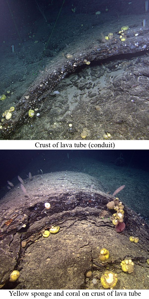
Une fois sur le fond nous avons vite eu un aperçu de la géologie particulière du site. Les roches étaient d'origine volcanique, confirmant l'hypothèse que cette montagne est en fait un volcan (inactif) éteint! Nous avons pu voir de magnifiques coulées de lave solidifié depuis probablement des millions d'années sur laquelle se dressait de nombreuses éponges et coraux. La montée a été ponctuée de zones riches en biologie sur un substrat de lave, à des zones plus pauvres sur des sols recouverts de boue et de sable. Les géologues comme les biologistes ont été émerveillés par le paysage qu’on a rencontré par moment. Il faut noter que la protection des monts sous-marins est très importante au niveau international mais que ceux-ci restent encore peu connu. Nous avons collecté ce matin les premières images et échantillons d’un mont sous-marin dans le Canada Atlantique! (bon… techniquement on était en zone internationale mais le cœur nous dit bien que c’est le Canada…).

Nous avons, comme dans nos plongées précédentes, vu un grand nombre d’espèces rares, incluant la découverte possible de nouvelles espèces. L’image ci-contre montre un exemple d’éponge colorée inconnue de nos biologistes marins. Nous avons vu des poissons dont quelques chimères. Nous avons collecté tellement d’organismes intéressant que nos boîtes à échantillon se sont remplies pour la première fois avant la fin de la plongée, rendant les biologistes frustrés de ne pas pouvoir collecter par la suite certains coraux et éponges uniques.

La plongée va se terminer vers 21h ce soir et nous nous rendrons alors au site suivant qui va permettre d’explorer des montagnes sous-marines plus petites, un peu à l’ouest de notre position actuelle. A suivre...

Sunday, July 18, 2010

Orphan Knoll Dive 1 : Orphan Seamount

The Orphan Seamount, found 620 Km east of St. John’s, NL, is a 2000m tall submarine feature that starts at a depth of 4500m.


Even though the Orphan Seamount has never been explored or studied, the shape and relation to Orphan Knoll suggests that it is probably a volcanic seamount.

In 2001 the USCG Healy collected high resolution multibeam imagery of the Orphan seamount and the SE ridge of the Orphan Knoll.

The CCGS Hudson and CSSF ROPOS are being used to collect biological, geological and seismic data on the Orphan seamount.

The dive plan for the Orphan Seamount will start on the NE side of the seamount and finish on the top of the seamount. The dive site and the dive plan is shown in the images below.


Seamounts near Newfoundland and Labrador have not been studied with the aid of remotely-operated vehicles (ROVs) before. The CSSF ROPOS is an ROV that can reach depths of ~5000m below sea level. The current floatation package installed allows ROPOS pilots to dive 3000m below sea level.

Seamount’s in other areas of the world have shown to be hotspots of biodiversity for many different types of invertebrates, including cold-water corals and sponges.

These invertebrates are living on unique and sometimes hostile substrate (e.g. hydro-thermal vents, black smokers, etc.).

The geological constitution and origin of this seamount coupled with unknown deep-sea biological fauna make exploring the Orphan Seamount an exciting adventure!

Flemish Cap Complete

The last dive on Flemish Cap was certainly not the least. This one dive held what taxonomists believe to be 2 entirely new species of cold-water corals (right). After struggling to reach the bottom because of the strong deep-ocean currents in this area, ROPOS took a few critical samples and began the arduous 12 hr journey up the slope towards the top of the cap. This dive spanned almost 1200 m of water depth from beginning to end and displayed a vast array of habitats, ranging from cliff side terraces lined with complex glass sponges and never before seen coral species to sandy bottoms which were comparatively devoid of life. The dive finished strong at 1300 m by providing scientists on board with a view of spectacularly dense beds of large white sponges of the family Geodiidae. Closure areas implemented by NAFO in this area were based on by-catch records of this habitat forming sponge (left). For more images from this dive click here (FCP6).

Despite weather and emergency delays in schedule, the dives on Flemish Cap have proven successful. These dives have given researches a glimpse into the deep waters of the slope ringing the Flemish Cap. Taxonomic samples have provided voucher specimens for video analysis that will take place once on shore. Incidentally, these collections have lead to some exciting discoveries; including 11 possibly new species and many more rarely encountered organisms. Geological samples collected and habitat classification conducted on board during dives in Flemish Cap will provide some insight into the geological origins of the cap while simultaneously enhancing our understanding of the driving factors affecting the distribution of deep-sea organisms in the area.

As well, 2 dives were specifically focused on surveying key portions of recent NAFO closure areas. The first of these dives on Flemish Cap successfully investigated the impact of trawling gear on vulnerable marine species. The data generated by transects run through both trawled and un-trawled ocean bottom within the footprint of an EU trawl survey conducted in the area in 2007, will provide researchers with some indication of the sustained legacy that trawling may have on deep-sea sponges and corals and other associated organisms. The second closure area dive was particularly interesting as it provided a glimpse into an undisturbed world of habitat forming sponges. Data from this dive will be used to modify existing models of sponge distribution and will assist in describing the species associated with these important biological features.

We are currently making the 9 hr steam north to begin a series of dives at Orphan Knoll. Shawn Meredyk, a Memorial University student conducting a Masters of Science Degree in Environmental Science specializing in the surficial geology and marine biology of Orphan Knoll, will provide a summary of activities for the first dive at this never before visited location.